Vincetoxicum forsteri (syn. Tylophora linearis)

Another species on our search radar in October 2021 (see previous post about Calotis glabrescens) was the twining vine Vincetoxicum forsteri (until 2018 known as Tylophora linearis), which is listed as endangered under the EPBC Act (Cth) and the Nature Conservation Act (Qld).  This very cryptic twiner of the Apocynaceae family was first described by Paul Forster of the Queensland Herbarium in 1992 from collections made in south-east Qld only four times, in 1913, 1914, 1960 and 1969 (Forster, Binns & Robertson, 2004).  A small number of populations were discovered in central NSW around 2003 (Forster, Binns & Robertson, 2004), and the species is now relatively well-known in that state (where it has been collected extensively by the outstanding RPS ecologist Mark Aitkens).  But until recently V. forsteri had remained elusive in Queensland since 1968.

However, a GHD survey in 2018 in the Gore-Karara-Goldfields area found one individual growing on a rabbit fence on the boundary of Durakai State Forest.  Therefore, during targeted protected plant surveys conducted by the Astrebla/Red Ash/GHD botany team in 2021, V. forsteri was one of the species we had high hopes of finding.

Eureka!

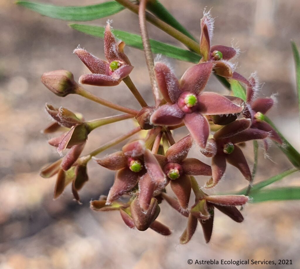
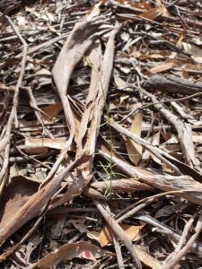
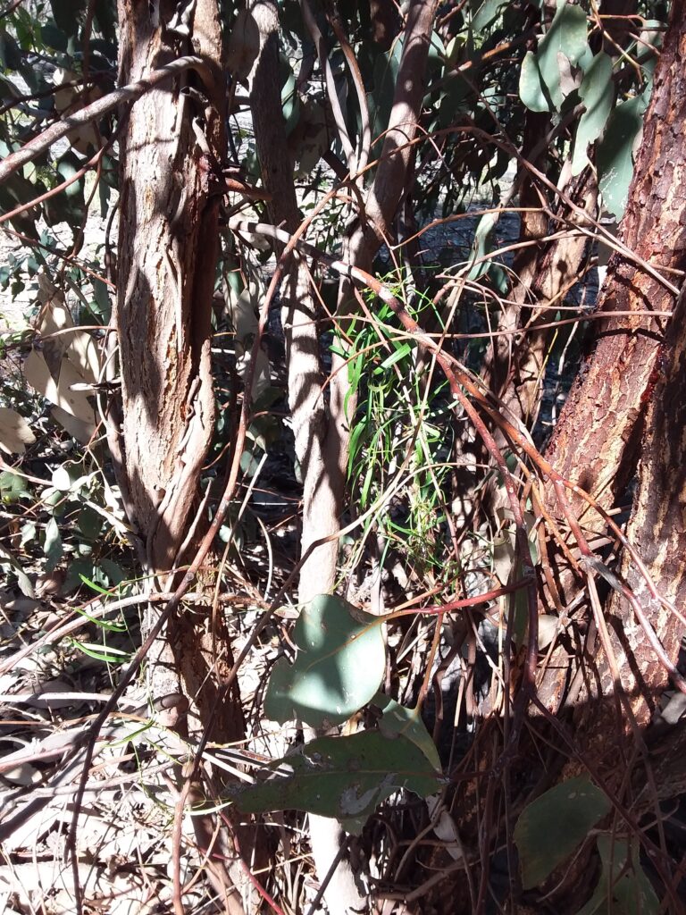
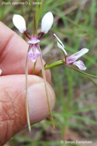
Well, we found them!  Nearly 300 stems in four main populations occupying almost 90 ha.  It is an extraordinarily difficult species to detect unless you slow your survey speed right down, because it is very slender (stems ~3 mm dia., leaves only a few mm wide and up to 10 cm long) (see pic below).  In addition, it tends to twine up dense shrubs or coppicing trees, so is easily lost to sight among coarser vegetation.  If it is flowering, the purple flowers will generally make it more easily detectable.  It is my firm belief that unless protected plant surveys targeting this species are conducted at suitably slow speeds, this species will almost certainly be missed (which I’m sure occurs from time to time).

Vincetoxicum forsteri flowers
A photo illustrating the very slender growth form of V. forsteri

Habitat

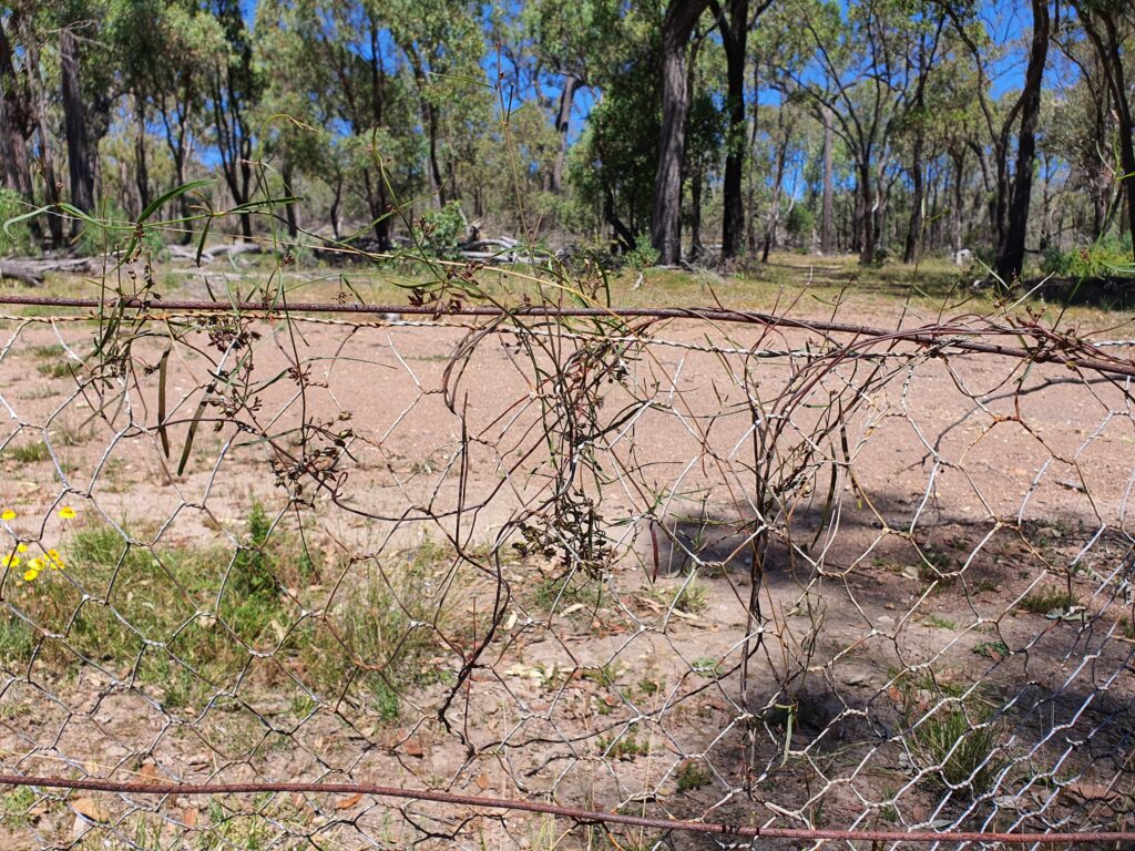
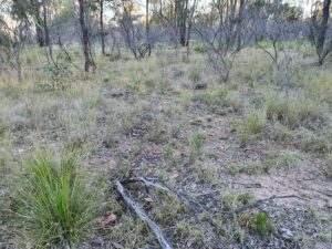
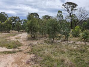
Our surveys found V. forsteri in two main vegetation types, open forest dominated by Eucalyptus fibrosa subsp. nubilis with E. sideroxylon (RE 13.11.5) and open forest dominated by E. dealbata with E. crebra (RE 13.11.3).  We also found a number growing on the mesh fences erected decades ago to control rabbits (but none on standard barbed wire fences).  Some had even started to grow on the new so-called ‘cluster fences’ recently erected across the landscape in this district with massive funding from government.  These fences prevent the widespread movement of macropods and other native mammals, and I predict they will have a massively detrimental impact on many least concern species in the area – but that is a topic for another blog!

Vincetoxicum forsteri growing on a rabbit-proof fence near Durikai State Forest

We found V. forsteri stems twining in the following situations:

  • The most common species we found it twining on was Olearia canescens, usually dead but standing
  • Vincetoxicum forsteri was also frequently found climbing coppicing E. fibrosa stems (see pic – many of the areas surveyed are the subject of private logging ventures),
  • More uncommonly it was found climbing on Acacia leiocalyx or A. fimbriata shrubs, either alive or dead (but still standing).

In the survey area, these habitat types occur in a mosaic with open forest dominated almost exclusively by Corymbia citriodora (RE 13.11.6). We rarely found Vincetoxicum forsteri in association with C. citriodora – it appears to have a clear preference for habitat occupied by ironbarks, and E. dealbata.

We also found it along the verges of logging tracks.

Vincetoxicum forsteri has been previously associated in the main with dense shrubland (Forster et al., 2004).  However, the open forest habitats in which we found these V. forsteri populations did not have dense shrub layers – in general, these open forests had very sparse to sparse shrub layers, with clear visibility for 50 m or more in most directions.  We did not find any plants in the nearby areas characterised by a dense Olearia canescens shrub layer.  This could be because the dense habitat makes it harder to detect, although overall 4 botanists walked just over 500 km of transects for this survey, of which at least 80 km was in areas with dense O. canescens – so these areas were well-surveyed.

Most individuals were found in areas where logging was active – although it is not known how populous the species was prior to logging, which is believed to have been practiced here for many decades.

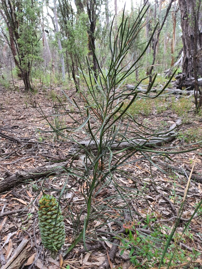
It is interesting to note that in this area, V. forsteri is present with extensive populations of the vulnerable cycad Macrozamia conferta, another species whose populations we were mapping, and which co-occurs with forestry activities.  This cycad is endemic to the Durikai-Talgai-Bringalily State Forest area, and this population is believed to be the largest on private land.

Vincetoxicum forsteri twining on a coppicing Eucalyptus fibrosa
Macrozamia conferta growing in the same preferred habitat for Vincetoxicum forsteri

References

Forster, P.I., Binns, D. and Roberston, G., 2004, Rediscovery of Tylophora linearis P.I. Forster (Apocynaceae: Asclepiodoideae) from New South Wales, with revision of its conservation status to vulnerable.  Austrobaileya 6 (4): 942-946.

Calotis glabrescens (white burr-daisy) – critically endangered daisy

In early October 2021, I undertook four weeks of protected plant surveys in the Karara-Cement Mills-Gore-Goldfields area, immediately to the south of Durakai State Forest, approximately 40 km west of Warwick in south-east Queensland.  The surveys were undertaken in company with Carly Sugars and Peter Moonie of Red Ash Consulting, and George Brady from GHD (Astrebla was contracted to GHD for this work).  In total we walked over 500 km of meandering transects during these surveys, in generally beautiful south-east Queensland spring weather!  It was a complete joy!

One of the species being targeted was Calotis glabrescens C.T. White (white burr-daisy), a small daisy listed as critically endangered under the Queensland Nature Conservation Act 1992 (but not listed under the EPBC Act).

Calotis glabrescens

Presumed extinct

Until recently, this species was listed under the NC Act as presumed extinct, as there were only two records.  The species had been described from one collection by Cyril T. White in 1946 (the Queensland government botanist who succeeded Bailey).  White had collected the plant in late September from near Bybera, in what is now Whetstone State Forest, noting it was ‘moderately common in open forest land’.  The next collection was in November 1997 by the Queensland Herbarium, who noted it was a ‘low herb to 10 cm tall with pinkish inflorescences, uncommon, scattered at site’.  This collection came from approx. 18 km south-west of Leyburn.

The species was not collected again after 1997 until 2 records in 2020 (strangely, these have disappeared from AVH since November 2021), from Durikai State Forest and another site south-west of Leyburn. There are no records from outside Qld, although the excellent ‘Plants of Western NSW’ book (Cunningham, Mulham, Milthorpe & Leigh, 1992) claims there is one record from the Bourke district (Plant Net has no entry for this species, so the source of this record is unclear – it would be a substantial range extension if confirmed).

Our survey found a small population of these plants approximately 7 km south-west of Karara, just north of the Cunningham Highway (thanks to eagle-eyed Peter Moonie for finding them in the first few steps of what would be 500 km of transects!!).

There is little recorded on this species, and no photographs are publicly available, so this blog seeks to provide sufficient information to assist in the planning of targeted surveys for Calotis glabrescens, and in its field identification.

Simon Danielsen (kneeling) and Peter Moonie (on ground) confirm the presence of Calotis glabrescens at a site near Karara

Habitat

Collection records for the species associate it with open forest and semi-cleared areas containing species such as Eucalyptus moluccana, E. sideroxylon, E. viridis and the wattles Acacia montana and A. ixiophylla.  The 1997 collection notes state it was found in ‘very tall woodland’ – I have visited the site of this record, and found that, using the current method for classifying vegetation communities used by the Qld Herbarium (based on Specht’s structural forms), it is not even close to ‘tall’, the canopy having a median height of approx. 15-18 m.

The 1997 collection notes also associate it with ‘traprock’ – this is a type of metamorphic rock known from the Warwick area (as with C. glabrescens, there is little to no information publicly available about this rock type).

C. glabrescens habitat at the 1997 collection site

Our survey found 15 plants growing on an undulating plain beside a dirt track, on a hard-setting pale clay loam, on the edge of a large clearing (but in the clearing, not in the adjacent woodland).  Adjacent woodland was co-dominated by E. moluccana and E. dealbata, and was relatively low (median height of 10-15 m). The parent rock was metamorphic and the pre-clear regional ecosystem was RE 13.11.8 (Eucalyptus melliodora and/or Eucalyptus microcarpa/ E. moluccana woodland on rolling hills, depressions and lower slopes around drainage lines, on metamorphics) (Qld Herbarium, 2021).

Habitat at our 2021 Calotis glabrescens collection site

Species identification notes

Calotis glabrescens is a small daisy growing 15-20 cm tall. It superficially resembles a number of other Calotis spp., mostly C. cuneata and C. scapigera.  However, it should be relatively straightfoward to field-identify it, using the Calotis key in Keybase prepared by Ailsa Holland.  There is also a useful illustration of the achenes of a number of Calotis spp. including C. glabrescens on p. 654 of Plants of Western NSW (Cunningham et al., 1992)

The major identification features (as outlined by Ailsa Holland) are:

  • The plant is relatively gracile – generally 15 cm tall but may extend to 20 cm, with cauline leaves and lacking a distinct basal rosette.  It does not have stolons.
  • Flower heads are distinctly pedunculate, with peduncles >1cm long, and ray florets >2.5 mm long.
  • The rays are white (may be pinkish) and disc florets are yellow (see pic above).
  • Achenes lack scales (wings) – achene scales should be obvious, they are flaps of tissue that extend upwards from the crown of the achene.
  • C. glabrescens achenes have 2-9 longer, rigid primary awns arranged around the outside edge of the achene crown – these awns have retrose (ie downward pointing), translucent barbs (see pics of achenes below).
  • In addition to the primary awns, there are several secondary awns – these lack the barbs of the longer primary awns.
  • In addition, the awns of C. glabrescens are NOT joined with each other at the base.
  • The achenes are generally as long as they are wide i.e. the horizontal and vertical axes at their longest points are approx. the same length (don’t include the spread of the awns in this measurement).

Also, look for leaves that are generally entire, but that sometimes have a single marginal tooth.

Calotis glabrescens achene – side view
Calotis glabrescens achene – top view

Survey timing

Flowers and particularly mature achenes are likely to be essential to identify this species with any certainty.  Our survey was conducted in October 2021.  Other collection records are from 20 September through to mid-November.

Survey challenges

This species is difficult to survey for because it is physically small and may be dwarfed by the grasses and other herbs it occurs in association with.  In addition, it may be present with other superficially similar Calotis spp., which may be abundant and so may desensitise those searching, who are looking for small Calotis individuals with entire leaves and flowers with white ray florets and yellow discs. Apparently suitable habitat is also common within its geographic range – therefore, there may be large areas to cover. 

Therefore, it may be easy to dismiss C. glabrescens as C. cuneata or C. scapigera (which both have stolons and serrated leaves in a basal rosette).  There is only one way to survey properly for this species – slowly and carefully. 

References

Australasian Virtual Herbarium (AVH), 2022, The Australasian Virtual Herbarium.  Council of the Heads of Australasian Herbaria.  https://avh.chah.org.au/.

Cunningham, G.M., Mulham, W.E., Milthorpe P.L. and Leigh, J.H, 1992, Plants of Western New South Wales, CSIRO Publishing, Melbourne.

Queensland Herbarium, 2021, Regional Ecosystem Description Database (REDD), version 12.0, Department of Environment and Science, Brisbane.

White, C.T., 1946, Contributions to the Queensland Flora, No. 9. Proceedings of the Royal Society of Queensland 57: 30.


Queensland’s Flora Trigger Mapping

There has been much controversy recently in relation to Queensland’s flora trigger maps, and the requirement to commission a survey by a suitably qualified person before clearing.

It has been alleged that this law will lock up country used for grazing and farming, and make it more difficult for landowners to manage their properties.  Some of the criticism has also confused things such as PMAVs and category X mapping, which are an instrument under the Vegetation Management Act, with the flora trigger map survey requirements, which fall under the Nature Conservation Act.  PMAVs and category X vegetation mapping have no relevance under the Nature Conservation Act.

Flora trigger maps are aimed entirely at flora species listed as near threatened, vulnerable or endangered/critically endangered.  Common flora species (labelled ‘least concern’ under the Nature Conservation Act) and plants not native to Australia are not controlled under the flora trigger map system.

Northern donkey’s tail, a near threatened orchid from the Atherton Tableland

The flora trigger map system was put in place by the Newman government in 2014 to ensure that areas considered to be at ‘high risk’ for these protected species were surveyed before being cleared.  It has been illegal to clear threatened plants in Queensland without a permit since 1992 at least – this law simply ensures that it is compulsory that areas considered to be likely to contain threatened plants are surveyed prior to clearing.

Exemptions

However, landowners should be aware that there are a number of exemptions that protect them and allow them to continue to undertake routine management activities in high risk areas without requiring a survey.

If the exemption covers your intended activity, you WILL NOT NEED a flora trigger map survey under the Flora Survey Guidelines – Protected Plants, even if the area is within a blue mapped area.

These exemptions are summarised at:

https://www.ehp.qld.gov.au/licences-permits/plants-animals/protected-plants/agriculture-primary-industries-sector.html#what_exemptions_exist

They are outlined fully in the Nature Conservation (Wildlife Management) Regulation 2006, chapter 4 part 3:

https://www.legislation.qld.gov.au/view/html/inforce/current/sl-2006-0205#ch.4-pt.3

These exemptions include (accurate at the time of writing on 8 September 2019 and NOT intended to constitute legal advice) taking (ie clearing/removing/killing) a protected plant for the following…

(words in bold are those that should be taken careful note of, as they add an essential element to the interpretation of the exemption)

For grazing (Section 261P)

If the plant is consumed by grazing stock, the exemption applies to:

    • freehold land – if the grazing is authorised/permitted under law
    • other land – if the grazing is authorised/permitted under a lease, permit, license or other authority or exemption.
Routine maintenance (section 261zc)

Routine maintenance includes slashing, mowing, pruning/trimming for:

    • existing infrastructure (eg buildings/built structures, fences, pipelines, roads, stockyards, tracks, watering facilities, constructed drains)
    • plantation management (if previously cleared legally)
    • cropping (if previously cleared legally).
Firebreaks/fire management lines (section 261zd)

To establish or maintain a firebreak or fire management line, where:

    • the firebreak is to protect infrastructure (other than a fence, road or track) and is no more than 1.5 times the height of the tallest adjacent vegetation, or 20 m (whichever is the greater).
    • the fire management line is necessary and is no wider than 10 m.
Clearing under a self-assessable code (Section 261ZE)

If you are clearing under a self-assessable clearing code under the Vegetation Management Act 1999 section 19O (1) and (2) for:

    • thinning
    • managing weeds
    • managing encroachment.
To avoid or reduce the risk of serious damage (Section 261B)

To avoid or reduce the risk of serious damage to buildings or property (eg structures or personal property) where:

    • it is necessary and reasonable to take the plant to avoid or reduce the imminent risk of serious damage, AND
    • If the damage is not prevented or controlled, a person may suffer significant economic loss, AND
    • the taking cannot reasonably be avoided or minimised.
By fire under the Fire & Emergency Services Act (S.261C)

If the clearing is done under the Fire and Emergency Services Act 1990, where:

    • it is part of a reasonable action by an authorised fire officer as defined under that Act, OR
    • the person takes the plant by lighting a fire that is authorised under a notification or permit issued under the Fire and Emergency Services Act 1990, and that fire is necessary for hazard reduction.

There is also an exemption for taking protected plants for fodder (section 261U), but it does not apply to endangered or vulnerable plants.

NOTE – THE ABOVE IS OFFERED FOR GENERAL INFORMATION ONLY AND DOES NOT CONSTITUTE LEGAL ADVICE.

ALWAYS CONSULT THE RELEVANT ACT AND/OR A GOVERNMENT OFFICER AND/OR YOUR LEGAL ADVISOR PRIOR TO CLEARING.

Clearing that does not meet the exemptions

If your clearing does not meet any of the exemptions (see the Nature Conservation (Wildlife Management) Regulation 2006 for the full list), you should obtain a flora trigger map for the intended clearing area from:

https://www.ehp.qld.gov.au/licences-permits/plants-animals/protected-plants/map-request.php

Under section 261z, if your clearing area is NOT mapped as a high risk area, you can clear without a survey provided:

    • you are not aware of the presence of any threatened plants in the area to be cleared,
    • you clear within 12 months of the date of receiving the flora trigger map,
    • you keep the flora trigger map in your records for at least 5 years from the date the clearing starts.

Of course, you must also satisfy yourself that the clearing is legal under other applicable laws, in particular the Vegetation Management Act.

If your clearing area IS within a mapped as a high risk area (and doesn’t meet an exemption), you will be required to commission a flora survey by a suitably qualified person.

If that survey finds that threatened plants are NOT present, you simply submit the survey report to the government at least one week prior to the clearing commencement date, and no later than 12 months after the flora survey was completed.

If threatened plants are present, it may be possible to plan the clearing such that it can be demonstrated those plants will not be impacted.  Alternatively, an offset may be acceptable.

Engaging a ‘suitably qualified person’

If your clearing area is within a mapped high risk area AND doesn’t fall under an exemption, you must commission a survey by a suitably qualified person.

You should always ask this person to prove they are suitably qualified prior to engaging them – a suitably qualified person must meet the requirements outlined in section 4 of the Flora Survey Guidelines, available at:

https://www.qld.gov.au/__data/assets/pdf_file/0028/99901/gl-wl-pp-flora-survey.pdf

Ideally, this person will be able to produce a pre-approval letter from the Chief Executive of the Department of Environment and Science agreeing that they are a suitably qualified person.  In addition, they should have completed similar flora trigger map surveys previously.

I have pre-approval as a suitably qualified person under the Flora Survey Guidelines and have conducted over 30 flora trigger map surveys since 2015.  If you wish to discuss your flora trigger map survey requirements, please don’t hesitate to contact me on:

Email: simon@astrebla.com or

Phone: 0423 706 440

Or use the Contact page on this website.

Welcome to Astrebla!

Welcome to the new website for Astrebla Ecological Services!

astrebla

Astrebla Ecological Services has been operating since 2015, offering big-name botanical service at a sole-trader rate!

After 10 years with one of the world’s top 50 engineering companies, Simon Danielsen established Astrebla to meet a number of key markets gaps:


  • To provide ‘on-demand’  Principal Botanist services to established consultancies (ie when botanical staff are on leave or otherwise not available).
  • To provide experienced, affordable ecological advice to landowners and developers.
  • To provide a botanical survey and impact assessment reporting service to developers and proponents of infrastructure and mining projects who wish to assemble and manage their own EIS team.

Astrebla aims to provide these services in a friendly, down-to-earth manner, and at an affordable rate!

In addition, through regular blogs this website will aim to provide information for other botanists that may be useful in the ongoing challenge of surveying, interpreting and reporting on Australian botany!