Workshops are held at The Hut, 47 Fleming Road, Chapel Hill, Brisbane.
This is the only publicly available, northern Australian grass-focused ID course based on hands-on microscope learning offered in Australia!
Learn to confidently recognise up to 20 major northern Australian grass genera & their ID features.
This course is designed for ecologists who conduct vegetation surveys & need to reliably identify grasses to species with scientific accuracy and consistency.
However, it is also suitable for anyone who has some background in grass ID and who wishes to extend their knowledge and skills base.
If you are grass beginner or novice, and don’t intend to delve into the field of grass ID in future, you may find this course too detailed and fast-paced – but you are still welcome!
You will use a stereo microscope (provided) to gain familiarity with the main diagnostic feature of grasses – the spikelet. You will also gain skills in interpreting typical grass inflorescence types.
By becoming familiar with a broad range of grass spikelets, you can confidently recognise those features in the field using a simple hand lens.
At the completion of this course, you will:
Be familiar with up to 20 of the more common grass genera of northern Australia & the morphological concepts underpinning their ID (primarily C4 grasses).
Be able to recognise spikelet & inflorescence features & interpret the botanical language used to describe them.
Be able to find those features in grasses you examine in the field using a hand lens.
Be able to negotiate digital and dichotomous keys with more confidence and accuracy (and greater speed). These skills are transferable to other families.
Most importantly, you will have built a solid foundation on which to continue a lifetime of independent learning in grass identification & botany.
This is a unique opportunity to learn basic grass ID and microscope dissection skills from an ecologist with 20 years’ experience.
The course notes (see examples below) provide clear ID pointers using microscope images that will assist you in your ID endeavours for years to come!
Course details
Course cost = $845 GST inc. for 2 days (8 am – 5 pm).
You will need to take a laptop (or you can use your phone) so that you can view the digital course notes and keys.
Course format is simple – a presentation explaining a particular grass genera or tribe, followed by a hands-on session with microscopes and samples of the target genera/tribe. Each student will have their own microscope.
Class size is limited to 10 students.
Lunch (vegetarian and non-vegetarian sandwiches), snacks and morning/afternoon tea will be provided.
Each participant will be provided with detailed digital course notes including microscope photographs illustrating key features of 20 grass genera (see below).
In addition, each participant will receive to keep:
a pair of forceps for dissecting spikelets,
a pocket metal ruler ideal for use in field IDs.
Contact Simon at simon@astrebla.com or on 0423 706 440 for further information
This course will be conducted by Simon Danielsen, a field botanist & ecological consultant with 20 years’ experience in botanical field surveys & identifications across northern Australia.
Simon has run his own ecological consultancy operation (Astrebla Ecological Services) for 9 years & is highly experienced in vegetation mapping, threatened plant surveys & the field identification of grasses & other plants. In 2014, he spent a year in the ID room at the Bangkok Forestry Herbarium in Thailand, completing over 400 botanical determinations in that time.
There has been much controversy recently in relation to Queensland’s flora trigger maps, and the requirement to commission a survey by a suitably qualified person before clearing.
It has been alleged that this law will lock up country used for grazing and farming, and make it more difficult for landowners to manage their properties. Some of the criticism has also confused things such as PMAVs and category X mapping, which are an instrument under the Vegetation Management Act, with the flora trigger map survey requirements, which fall under the Nature Conservation Act. PMAVs and category X vegetation mapping have no relevance under the Nature Conservation Act.
Flora trigger maps are aimed entirely at flora species listed as near threatened, vulnerable or endangered/critically endangered. Common flora species (labelled ‘least concern’ under the Nature Conservation Act) and plants not native to Australia are not controlled under the flora trigger map system.
Northern donkey’s tail, a near threatened orchid from the Atherton Tableland
The flora trigger map system was put in place by the Newman government in 2014 to ensure that areas considered to be at ‘high risk’ for these protected species were surveyed before being cleared. It has been illegal to clear threatened plants in Queensland without a permit since 1992 at least – this law simply ensures that it is compulsory that areas considered to be likely to contain threatened plants are surveyed prior to clearing.
Exemptions
However, landowners should be aware that there are a number of exemptions that protect them and allow them to continue to undertake routine management activities in high risk areas without requiring a survey.
If the exemption covers your intended activity, you WILL NOT NEED a flora trigger map survey under the Flora Survey Guidelines – Protected Plants, even if the area is within a blue mapped area.
These exemptions include (accurate at the time of writing on 8 September 2019 and NOT intended to constitute legal advice) taking (ie clearing/removing/killing) a protected plant for the following…
(words in bold are those that should be taken careful note of, as they add an essential element to the interpretation of the exemption)
For grazing (Section 261P)
If the plant is consumed by grazing stock, the exemption applies to:
freehold land – if the grazing is authorised/permitted under law
other land – if the grazing is authorised/permitted under a lease, permit, license or other authority or exemption.
Routine maintenance (section 261zc)
Routine maintenance includes slashing, mowing, pruning/trimming for:
To establish or maintain a firebreak or fire management line, where:
the firebreak is to protect infrastructure (other than a fence, road or track) and is no more than 1.5 times the height of the tallest adjacent vegetation, or 20 m (whichever is the greater).
the fire management line is necessary and is no wider than 10 m.
Clearing under a self-assessable code (Section 261ZE)
If you are clearing under a self-assessable clearing code under the Vegetation Management Act 1999 section 19O (1) and (2) for:
thinning
managing weeds
managing encroachment.
To avoid or reduce the risk of serious damage (Section 261B)
To avoid or reduce the risk of serious damage to buildings or property (eg structures or personal property) where:
it is necessary and reasonable to take the plant to avoid or reduce the imminent risk of serious damage, AND
If the damage is not prevented or controlled, a person may suffer significant economic loss, AND
the taking cannot reasonably be avoided or minimised.
By fire under the Fire & Emergency Services Act (S.261C)
If the clearing is done under the Fire and Emergency Services Act 1990, where:
it is part of a reasonable action by an authorised fire officer as defined under that Act, OR
the person takes the plant by lighting a fire that is authorised under a notification or permit issued under the Fire and Emergency Services Act 1990, and that fire is necessary for hazard reduction.
There is also an exemption for taking protected plants for fodder (section 261U), but it does not apply to endangered or vulnerable plants.
NOTE – THE ABOVE IS OFFERED FOR GENERAL INFORMATION ONLY AND DOES NOT CONSTITUTE LEGAL ADVICE.
ALWAYS CONSULT THE RELEVANT ACT AND/OR A GOVERNMENT OFFICER AND/OR YOUR LEGAL ADVISOR PRIOR TO CLEARING.
Clearing that does not meet the exemptions
If your clearing does not meet any of the exemptions (see the Nature Conservation (Wildlife Management) Regulation 2006 for the full list), you should obtain a flora trigger map for the intended clearing area from:
Under section 261z, if your clearing area is NOT mapped as a high risk area, you can clear without a survey provided:
you are not aware of the presence of any threatened plants in the area to be cleared,
you clear within 12 months of the date of receiving the flora trigger map,
you keep the flora trigger map in your records for at least 5 years from the date the clearing starts.
Of course, you must also satisfy yourself that the clearing is legal under other applicable laws, in particular the Vegetation Management Act.
If your clearing area IS within a mapped as a high risk area (and doesn’t meet an exemption), you will be required to commission a flora survey by a suitably qualified person.
If that survey finds that threatened plants are NOT present, you simply submit the survey report to the government at least one week prior to the clearing commencement date, and no later than 12 months after the flora survey was completed.
If threatened plants are present, it may be possible to plan the clearing such that it can be demonstrated those plants will not be impacted. Alternatively, an offset may be acceptable.
Engaging a ‘suitably qualified person’
If your clearing area is within a mapped high risk area AND doesn’t fall under an exemption, you must commission a survey by a suitably qualified person.
You should always ask this person to prove they are suitably qualified prior to engaging them – a suitably qualified person must meet the requirements outlined in section 4 of the Flora Survey Guidelines, available at:
Ideally, this person will be able to produce a pre-approval letter from the Chief Executive of the Department of Environment and Science agreeing that they are a suitably qualified person. In addition, they should have completed similar flora trigger map surveys previously.
I have pre-approval as a suitably qualified person under the Flora Survey Guidelines and have conducted over 30 flora trigger map surveys since 2015. If you wish to discuss your flora trigger map survey requirements, please don’t hesitate to contact me on:
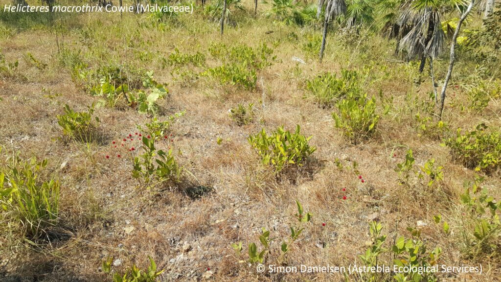
In May 2019 I conducted a survey with Chris Brock from Brock Environmental for the threatened shrub Helicteres macrothrix (Malvaceae) Cowie – previously known as Helicteres sp. Glenluckie Creek (N.B. Byrnes 1280).
This species is listed as endangered under both Northern Territory and Commonwealth legislation.
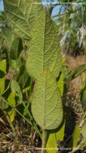
H. macrothrix is an erect, densely clumping subshrub growing to approximately 60 cm tall. The leaves and stems are covered with a dense indumentum of long, stellate trichomes (= hairs) with a diameter up to 4.5 mm wide (Cowie, I., 2011).
It is restricted to a small area approximately 80 km south east of Darwin, where it has been recorded from three main sub-populations in the Mt Bundey, Coomalie Creek and Lake Bennett areas (with an outlier north of Acacia Hills) (Australasian Virtual Herbarium, 2019).
Our survey was located north of Lake Bennett. As is often the case with threatened species surveys, the timing of the survey (late wet season/early dry season) and prior weather conditions (the Top End had a very dry wet season this year) were not optimal for flowering. However, we were pleased to find that this species appears to be quite readily identifiable (and observable) well into the dry season, in the absence of reproductive material and even after burning.
We found it closely associated with a combination of Eucalyptus tectifica woodland with Wildman siltstone (the latter being an early Proterozoic metamorphosed siltstone), growing among a tall, dense to sparse grassy ground layer generally dominated by Sarga intrans and Heteropogon triticeus with Schizachyrium fragile.
It was always present in lower landscape positions, on gently undulating run-on surfaces or on level plains isolated from adjacent slopes.
In general, it was growing in sparse to mid-dense groups (see picture above), but occasional outlying individual plants were observed, sometimes many hundreds of metres from the main population. However, within our survey area it was unfailingly associated with E. tectifica.
Some parts of our site had been burnt a few weeks prior to our survey. However, H. macrothrix appears to be one of the first plants to recover after fire, and sprouts that were identifiable to species and already a few inches tall were easily observable.
In fact, H. macrothrix regrowth was obvious in this situation, given that little other regrowth had yet occurred.
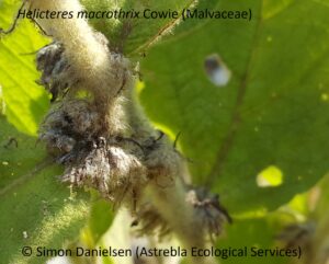
H. macrothrix is superficially similar to H. darwinensis and H. integrifolia but can be discriminated relatively easily from these in the absence of reproductive material, as it has:
an erect, multi-stemmed habit – c.f. H. darwinensis, a prostrate species,
crowded inflorescences (see picture above – the spent calyces are persistent),
very coarse, congested stellate hairs (macrothrix = large hairs) to 4.5 mm dia. – much larger than both H. darwinensis and H. integrifolia.
In addition, H. macrothrix is not associated with laterite (c.f. H. darwinensis) and only grows in sandy soils that are derived from granite (c.f. H. integrifolia).
The Northern Territory Herbarium (DNA) has prepared a number of excellent resources on this species, and should be consulted in relation to ID questions and in relation to survey design – in particular see:
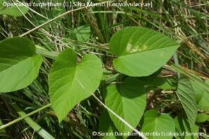
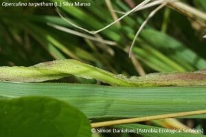
In February 2018, I undertook a targeted survey with taxonomist Bob Harwood for the vulnerable geophyte Typhonium praetermissum on the Gunn Point peninsula, approximately 30 km north east of the Darwin CBD. In addition, we also searched for the vine Operculina turpethum. And we found both of them!
Operculina turpethum is a twining vine growing to 4 m or more, recorded from various locations (mostly coastal and sub-coastal) across northern Australia, but primarily it is known from South East Asia. It had been recorded in 2000 from grassland at the rear of a low sand dune at Gunn Point, and our task was to determine if it was still present. Operculina turpethum is listed as near threatened in the NT.
We quickly located it, growing in the same grassland location as in 2000 (possibly from the same tuber). It was not flowering, however its presence in the same location as a previous confirmed record, and its conspicuously flanged/winged stems, suggested that is it highly likely to be O. turpethum.
This species was originally described by Linnaeus in 1753 as Convolvulus turpethum, but was split from that genus by Silva Manso in 1836.
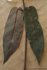
Typhonium praetermissum A. Hay (Araceae)
Typhonium praetermissum is a relatively cryptic perennial geophyte (i.e. a predominately subterranean herb) endemic to the Darwin/Litchfield area. It flowers and fruits in November and December, and appears to produce leaves only during the wet season, after which they quickly deteriorate and the plant disappears beneath the soil. The flowers are very delicate and exude an apparently unpleasant odour, but are quickly destroyed by ongoing wet season downpours, having a life of 1-3 days.
There are some major difficulties in locating and accurately identifying Typhonium spp.. Flowers are generally required to key to species, however these are rarely encountered. In addition, most species have leaves that display extreme morphological variations (as can be seen in the accompanying photos), making even tentative ID difficult.
However, Dr Matthew Barrett of the WA Dept. of Biodiversity, Conservation and Attractions has developed a DNA barcoding technique that allows accurate and unambiguous identification to species of sterile material. Consequently, representative collections of leaf material were made from within the population of Typhonium individuals observed during our survey at Gunn Point and send to Dr Barrett for analysis and identification.
As a result, the identification of the majority of the population observed to T. praetermissum was possible. In addition, a small number of T. johnsonianum were also confirmed present. Interestingly, of the many hundreds of individuals of both species observed during the surveys, only one individual had fruit – all of the remainder were sterile.
The population of T. praetermissum at this Gunn Point site was predominately located on lower run-off slopes in low woodland and woodland with a mixed species dominance, including Corymbia polysciada, Melaleuca viridiflora, Erythrophleum chlorostachys, Xanthostemon paradoxus, Lophostemon lactifluus and Gardenia megasperma. The ground layer was generally tall (to 2 m) and dense, dominated by perennial grasses and numerous herbs.
An interesting observation was that T. praetermissum was often present on disturbed surfaces, including spoon drains that are graded annually, and an old gravel pit.
In the photo to the left, Bob Harwood is pointing out a population of nearly 100 individuals we observed in a large gravel pit beside the main road.
T. praetermissum leaves are generally less than 5 cm long and those in the photo were almost all about 1-2 cm long, so they can be very difficult to spot among tall grass – but they are down there, believe me!
Typhonium johnsonianum A. Hay & S. Taylor (Araceae)
This species is very similar to T. praetermissum, but is less well known, being listed as data deficient in the NT. It has been recorded from the Alligator River floodplain, Kakadu National Park, and from the Humpty Doo and Noonamah areas. This survey represents the first collection from the Gunn Point area – as such, a range extension of approximately 30 km, which is relatively significant for a locally endemic plant with such a small range.
In general, T. johnsonianum displays less leaf-form variation than T. praetermissum – the leaves were invariably narrow triangular with a distinctive sagittate to hastate base, and a relatively short petiole. Some plants are more lanceolate, being cuneate to rounded at the base and lacking auricles.
Dr Ludwig Leichhardt was the principal player in what must be one of the greatest scientific adventures in the history of European settlement of Australia. On 1st October 1844 he departed from Jimbour Station, the most western European station at that time in Queensland (Jimbour is just north of today’s township of Dalby on the Darling Downs in south east Queensland), to travel to Port Essington, approximately 300 km north east of Darwin. At that time, Pt. Essington was the only European settlement in northern Australia.
He arrived at Pt. Essington just prior to the wet season, on 17th December 1845, after traversing 4800 km. However, only seven men arrived at Pt. Essington – John Gilbert, an ornithologist and a protege of Gould, was speared and died at a camp near the Nassau River, not far from today’s Kowanyama on Cape York Peninsula.
Leichhardt was a keen naturalist, and his diary is full of observations on plants, animals and geology. He was not a rich man, and had financed the expedition privately after government funding was withdrawn. On his return, he planned to sell many of his specimens to collectors in Europe in order to recoup some of his own expenditure on the journey.
However, on the 21st October 1845, just over one year since setting out from Jimbour Station and less than 2 months from their destination, disaster struck – three horses were drowned while crossing a creek beside the Roper River, near the modern township of Ngukurr, about 170 km east of Mataranka in the N.T.. Two days later, another horse drowned in a creek crossing.
The implication of these losses was enormous – Leichhardt was forced to abandon approximately 4000-5000 pressed specimens from the trip, as they did not have enough remaining animals to carry specimens and essential items like food and camping equipment.
Leichhardt wrote…
This disastrous event staggered me…The fruit of many a day’s work was consigned to the fire; and tears were in my eyes when I saw one of the most interesting results of my expedition vanish into smoke.
To William Philips, one of his companions, he estimated their monetary value to be £400-£500 (approx. $100, 000 in 2019).
The remainder of his specimens were consigned to a pack bullock. Two weeks later, they were approaching the south western tip of Arnhem Land, about 140 km north east of today’s township of Katherine. After travelling over rough sandstone country that tested their bullocks severely, the party entered a narrow gully with ‘some fine Nymphaea ponds and springs surrounded by ferns‘.
As Leichhardt related it…
Our bullocks had become so foot-sore, and were so oppressed by the excessive heat, that it was the greatest difficulty we could prevent them from rushing into the water with their loads.
One of them – that which carried the remainder of my botanical collection – watched his opportunity, and plunged into a deep pool, where he was quietly swimming about and enjoying himself, whilst I was almost crying with vexation at seeing all my plants thoroughly soaked.
So Leichhardt was reduced to tears twice in the space of a fortnight on account of his botanical collection! Indeed, Joseph Decaisne, who received some of these specimens at the Museum of Natural History in Paris, wrote that those he received were too badly damaged for exact study (Fensham et al., 2006), no doubt courtesy of the recalcitrant swimming bullock. Having spent countless hours myself collecting, pressing, labelling and recording plant specimens, I can still feel Leichhardt’s ‘vexation’ today!
Leichhardt’s legacy
Leichhardt’s expedition was one of the first to systematically sample such a large swathe of inland Australia, and the value of the samples he returned with, in addition to the detailed notes in his journal, were enormous.
Fensham et al. (2006) estimate the lost collection would have included well over 100 species new to science at that time, would have included a number of extensions to currently accepted ranges, and may have established as indigenous some flora species that are today thought to be exotic. They found…
Leichhardt may not have fulfilled his potential but commentators now regard Leichhardt as an extremely capable botanist who made a substantial and underrated contribution to the development of botanical knowledge in Australia…Leichhardt was a talented botanist and his significant contribution to Australian natural science should be recognised.
Glen McLaren retraced the Leichhardt journey in the early 1990s by horse, motorbike and eventually helicopter, and based a PhD on his findings. He summarised his findings on Leichhardt’s competency, both as a bushman and scientist, as follows (McLaren, My Greatest Regret, undated):
Firstly, armed with my navigational and cartographic findings I was able to state definitively that, given his paucity of equipment, Leichhardt’s mapping as well as latitudes and longitudes were most acceptable. He did not miss any major features.
Secondly, based on contemporary accounts, his journals and my field observations, Leichhardt’s bushmanship was unquestionably of the highest order, as he led the expedition the entire distance, selecting the route, finding water and securing campsites, often reconnoitering days in advance of the main party and finding his way back through trackless forest at night.
And finally, time has shown that Leichhardt’s scientific field achievements were of the highest order. He was unquestionably the most broadly educated and complete field scientist in Australian exploration history. Indeed, he was a true polymath and heir to von Humboldt.
Eremophila mitchellii, which Leichhardt mistook for a Vitex sp. (Fensham et al. 2006)
Some interesting facts about Leichhardt’s 1844-45 expedition include:
To protect his specimens, he wrapped them with green hide, which when it dried shrunk and bound them tightly, acting to protect them from the damage they would otherwise have endured being tied to the back of a horse or bullock (a transportation technique that had already destroyed the ornithologist’s primary sampling tool, his best gun).
Leichhardt commenced his epic journey with 17 horses and 18 pack bullocks – the latter carrying about 70 kg each. Loading these animals each morning took about 2 hours, and they often found (at least in the early days of the expedition) that the bullocks had strayed back to the campsite of the previous night, requiring someone (usually their native trackers, Charley and Brown) to retrace their steps and fetch them back (which then resulted in delays to departure of many hours).
The party departed with 550 kg of flour, 90 kg of sugar, 35 kg of tea, 9 kg of gelatine and 12 kg of gunpowder. They lost a considerable amount of flour when they tried to cross a large patch of brigalow scrub within a week of departing – the many sharp sticks and shrubs ripped their bags to pieces, as they are still liable to do today!
After this they always went around brigalow – however, Leichhardt encountered patches of brigalow and vine thicket that took days to skirt, indicative of the vast areas that once existed across central Queensland (in what is now called ‘the Brigalow Belt’).
In addition to plant collecting, Leichhart had to determine the route to be taken through uncharted country (he generally scouted ahead, sometimes spending days away from the main party), drive, load and unload bullocks (sometimes several times a day), determine longitude and latitude (no GPS!), complete his log, account for and apportion dwindling provisions, take part in nightly watches (they were frequently the subject of attention from the indigenous peoples whose territories they were passing through), and provide leadership in relation to the various strains and tensions that inevitably develop in such a party on such a strenuous and lengthy expedition.
Leichhardt had very little in the way of Flora’s to assist him in identifying plants (although even today, the only modern Flora to cover this area is the still incomplete Flora of Australia). His primary reference materials were Robert Brown’s Prodromus Florae Novae Hollandiae et Insulae Van-Diemen (1810) and Supplementum Primum Prodromi Florae Novae Hollandiae (1830), and de Candolle and de Candolle’s Prodromus systematis naturalis regni vegetablis.
There are believed to be at least 2800 specimens collected by Leichhardt over his career in herbaria around the world, of which 78 have been designated as types. However, Fensham et al. (2006) located only 36 plant specimens from the 1844-45 expedition in Australian herbaria, and 16 from that expedition that may be held in Australian or European herbaria (although there may be more in the Paris Herbarium, to which he sent most of his specimens after the expedition).
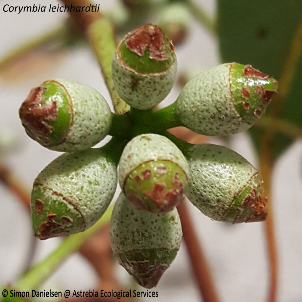
Leichhardt’s name has been honoured in at least 49 plant taxa, of which 21 are currently recognised names, including yellowjacket (Corymbia leichhardtii) – see below.
Corymbia leichhardtii buds, Evelyn Tableland
Leichhardt’s route took him through or very near the site of a number of modern towns and landmarks, including Warra on the Warrego Highway (beside which he camped), Chinchilla, Barakula State Forest, Taroom, the Arcadia Valley, Rolleston, Comet, the Oaky Creek mine (just to the east of Tieri), the Saraji mine, Moranbah, the Goonyellah Riverside mine, through the gap in the Burton range where the current North Goonyella accomodation village is located (Ellensfield Rd), Glenden (he named the Suttor River), the Suttor mine, Belyando Crossing, Sellheim (just to the east of Charters Towers), Normanton, Boorrooloa, Roper Bar and the Cooinda Lodge at Yellowwater in Kakadu National Park. They crossed the current location of the Arnhem Highway about 20 km west of Jabiru.
Even back then, wild buffalo were prevalent in the northern N.T. – Leichhardt noted numbers of buffalo as they neared Pt. Essington, and indeed their party managed to bring down a few (they were desperately short of food by then).
Leichhardt resources
For those interested in Leichhardt’s route, I recommend the Australian Dictionary of Biography website at http://adb.anu.edu.au/entity/8843.
This site has an interactive map of Leichhardt’s route in an embedded Google Earth display, with each campsite location and links to the diary entries of Leichhardt and a number of his companions for that day. You can follow his route exactly and read his observations and those of his companions as he traversed the country. In addition, the notes of Glen McLaren are available for each campsite.
I also recommend the following articles, on which I relied for some of the facts related in this blog:
Dowe, J.L., 2005, Ludwig Leichhardt’s Australian plant collections, 1842-1847. Austrobaileya 7(1): 151-163.
Dowe, J.L., 2005, Observations of Palms Made by the Botanist and Explorer Ludwig Leichhardt, During the Australian Overland Expedition of 1844-1845. Palms 49(4): 167-182.
Fensham, R.J., Bean, A.J., Dowe, J.L. and Dunlop, C.R., 2006, This disastrous event staggered me: Reconstructing the botany of Ludwig Leichhardt on the expedition from Moreton Bay to Port Essington, 1844-45. Cunninghamia 9(4): 451-506.
Glen McLaren also wrote a book on his findings in relation to Leichhardt:
McLaren, G., 1996, Beyond Leichhardt: Bushcraft and the Exploration of Australia. Fremantle Arts Centre Press, South Fremantle.
Probably the definitive book on the disappearance of Leichhardt, and highly recommended, is that of Darrell Lewis:
Lewis, D., 2013, Where is Dr Leichhardt? The greatest mystery in Australian history. Monash University Publishing, Melbourne.
The world of plants is truly amazing – I recently became aware for the first time of a genus that has been literally under my feet for years – the tongue ferns or Ophioglossum spp.!
I first became aware of these tiny ferns when they began popping up in my hanging plant pots! Soon I had a whole colony, and they transplanted well into tiny bonsai pots, although I had no idea what they were – there were only tiny, fairly non-descript leaves with blades about 10-15 mm long.
Finally, fruiting spikes emerged and they revealed their identity as ferns!
Those pictured here are Ophioglossum reticulatum L. (Ophioglossaceae), a tiny fern growing to 20 cm or so tall, and recorded from damp, shady situations among grass or on bare soil, often in eucalypt forest.
This species has been collected from Melbourne to the northern tip of Cape York Peninsula and west to Broome – it also occurs in New Zealand and in tropical and sub-tropical countries throughout the world.
It was first described by the father of taxonomy Carl Linnaeus in 1762 in his Species Plantarum.
The fruiting spikes (actually modified leaves) are shown in this image – they are approximately 5 cm tall, and their presence mark the members of Ophioglossaceae as quite different from other ferns – they are referred to by taxonomists as either fern allies or fern ‘oddities’.
This is because most ferns have the seed-bearing organs, or sporangia, arranged on the underside of the leaves/fronds. In the Ophioglossaceae, the sporangia are placed at the apex of a specialised leaf or fruiting spike.
Another distinctive feature of ferns not shared by Ophioglossum spp. is that their leaves do not unfurl – they merely lengthen from the rhizome.
I also recorded this species on a survey I conducted in 2018 on the Evelyn Tablelands, growing on basaltic soil in Eucalyptus tereticornis open forest.
Superficially, they looked very similar (but smaller) to the Typhonium praetermissum I had been surveying in the Darwin region a few months earlier.
These tiny leaves were barely noticeable among the leaf litter, but were spotted by my eagle-eyed mate Dave Hunter, whose curiosity and ability to pick out tiny orchids and other cyrptophytes is fast becoming legendary!
In 2018 Simon was privileged to work on a broad range of projects on sites in the Northern Territory, Queensland and New South Wales. Some of this work involved searches for threatened flora species, and in total, 19 threatened plant species were encountered. This included two endangered species, 14 vulnerable species, and three near threatened species. This blog includes some of the highlights!
Listed as vulnerable in NSW, scattered individuals were recorded from eucalypt grassy open forest along the upper edge of run-on slopes in the Raymond Terrace area, near Newcastle in NSW. The species epithet ‘chaetophora’ means ‘bristle-bearing’ in Greek and refers to the conspicuous hairs on the labellum, clearly visible in the photo on the left. ‘Pterostylis’ means ‘winged style’.
Tylophora rupicola P.I. Forst. (Apocynaceae)
Listed as endangered in Queensland and under the EPBC Act, this species is a rare slender twining vine distinguished by its small lanceolate, herbaceous, opposite leaves with purplish-red petioles and clear sap. It has been recorded from 16 locations between Cairns and Herberton – the Astrebla records represent a minor southward range extension to the existing collection records. A total of 76 plants were recorded, with one population of 50 plants.
Tylophora rupicola was recorded from low closed and open forests, mostly grassy, on rhyolite slopes in association with Lophostemon confertus,Acacia aulococarpa, Eucalyptus granitica,Corymbia abergiana,E. reducta,Allocasuarina littorlis, Syncarpia glomulifera and C. citriodora, always slightly upslope of rocky minor watercourses (regional ecosystems 7.12.30d and 7.12.66c).
Dendrobium fellowsii F. Muell. (Orchidaceae) (native damsel orchid)
This is an epiphytic orchid listed as vulnerable in Queensland. It was collected by Astrebla from the Evelyn Tableland, where it was growing on shrubs and trees with rough bark including Syncarpia glomulifera and Allocasuarina torulosa. Dendrobium fellowsii is a Wet Tropics endemic, and was first collected by John Dallachy, described as ‘perhaps the best Australian botanical collector’ by Joseph Maiden (he has at least 14 Queensland plant species named in his honour).
Dallachy collected it in the 1860s from the Cardwell area, and it was described by Baron Ferdinand von Mueller in 1870. Mueller named it after Thomas Howard Fellows, a short-termed Attorney General of colonial Victoria and later a Supreme Court judge. Dendrobium fellowsii is also known as Eleutheroglossum fellowsii (F. Muell.) M.A. Clem. & D.L. Jones.
This species was collected from Corymbia clarksoniana grassy low woodland at Arriga, approximately 10 km west of Mareeba. It has been recently de-listed in Queensland and is now listed as endangered only under the EPBC Act.
Tips to ID this relatively poorly documented species include (from Hacker, 1990, A Guide to Herbaceous and Shrub Legumes of Queensland):
This is the only Queensland species of Cajanus that is a trailing plant with a leaflet length:width ratio of greater than 5:1.
The lower leaf surface has frequent minute yellow circular resin glands, which are usually conspicuous.
The stems die back each year but grow to several metres long, and the leaves are well-spaced along the stem (at least the width of the leaflets).
The leaves are quite large relative to other Fabaceae trailing herbs/vines found in similar habitat – 90-110 x 12-22 mm with a petiole 25-130 mm.
Pods are strongly flattened, prominently purple-mottled, densely pubescent and with yellow glands on the surface.
Macrozamia conferta (D.L. Jones & P.I. Forster)
This species is listed as vulnerable in Queensland and under the EPBC Act. It was collected from freehold land near Durikai State Forest, approximately 40 km south west of Warwick, where it was relatively common within small areas. It was present in Eucalyptus sideroxylon and E. fibrosa subsp. nubila open forest on land zone 11 on a flat beside a small drainage line (RE 13.11.5), and E. dealbata low open forest with E. caleyi and Callitris endlicheri on the mid slope of a steep hill (RE 13.11.3).
Macrozamia conferta has a subterraenean trunk and leaves with a tightly spiral-twisted rachis. Leaflets are curved upward laterally into a clear ‘U’ shape (incurved). New growth was grey and pubescent. Over 50 individuals were present at each site within an area of less than 5000 m2. The image on the left is of a female cone.
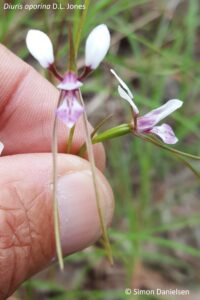
Diuris oporina D.L. Jones (Orchidaceae)
Diuris oporina is a relatively dainty, near threatened orchid collected from open forest and open woodland dominated by Corymbia citriodora and Eucalyptus portuensis (RE 7.12.30) in stony (rhyolitic) clay loam on the Evelyn Tableland in north Queensland. It was always associated with a grassy ground layer dominated by Themeda triandra. Astrebla counted 25 individuals from two populations.
Diuris oporina has until recently been thought to be restricted to the drier western ranges of the Atherton and Evelyn Tablelands in North Queensland. However, material collected as far back as 1953 (and apparently only identified recently) indicates this species has also been found in ranges in the vicinity of Airlie Beach and the Eungella Tableland, and from the Central Highlands in sandstone ranges of the Carnarvon Gorge and Palmgrove National Parks. These are significant range extensions, and indicate that much is yet to be learnt about this beautiful orchid.
Cycas armstrongii Miq. (Cycadaceae)
Cycas armstrongii is a cycad listed as vulnerable in the Northern Territory. It is relatively common in the Darwin region. Over 10, 000 plants were recorded within a few hectares in the population survey!
This cycad is relatively easily identified as it has flat to recurved (not revolute) leaflet margins, ovoid-globose pollen (male) cones and densely orange tomentose, pungent cataphylls (illustrated in the lower image – cataphylls are the young leaves). The mature adult leaf blades are green and shiny.
This species was named by the pre-eminent Dutch botanist Friedrich Miquel in 1868, just a few years before his death. Cycas armstrongii was named in honour of John Armstrong, a Kew Gardens botanical collector who had established a government garden at Port Essington in the 1840s.
Port Essington was an early attempt by the British government at settlement of the northern Australian coast, and is located approximately 200 km north east of Darwin. It is perhaps most famous as the terminus of Ludwig Leichhardt’s incredible expedition from near Dalby on the Darling Downs in Queensland, a journey of 4800 km through the (then) trackless interior of Queensland via Cape York Peninsula. Leichhardt arrived in Pt Essington on 17 December, 1945, after a journey of 14 months – surely one of the most incredible feats in Australia’s exploration history! You can now follow Leichhardt’s journey from a new interactive webpage at: http://adb.anu.edu.au/entity/8843
Aristida annua B.K. Simon (Poaceae)
This grass species is listed as vulnerable in Queensland and under the EPBC Act. It is a distinctive Aristida that is easily identified as it is the only annual of this genus with a convolute lemma and an open panicle. It was collected in the Minerva Hills, approximately 18 km north-west of Springsure in central Queensland, growing in black cracking clay with abundant basalt cobble in a Eucalyptus crebra low woodland.
It was immediately obvious that it was an unusual Aristida – the leafy section of the culms was only 20 cm long, the leaves were sparse (suggesting an annual), and the spikelets were noticeably small. The inflorescence was open, to 50 cm long by 20 cm wide.
Aristida annua was described in 1984 by the prolific Queensland grass taxonomist Bryan Simon, and to date is only known from 9 collections. It appears to be very rare, even locally – despite numerous Biocondition surveys conducted across black soil plains, rises and hillslopes in the immediate region over five days that week, this was the only plant observed.
Homoranthus porteri (C.T. White) Craven & S.R. Jones (Myrtaceae)
This species is listed as vulnerable in Queensland and under the EPBC Act. It is a shrub to two metres tall with opposite, closely spaced leaves to 10 x 1.5 mm and flowers usually growing in pairs with red/creamy bracteoles and a lobed yellow calyx.
It was collected from rhyolite rock pavement on the Evelyn Tableland, where it occurs as a dominant to sub-dominant component of low heathland, shrubland and low woodland in association with Eucalyptus lockyeri, E. shirleyii, Corymbia abergiana, Grevillea pteridofolia, Allocasuarina inophloia, Acacia aulococarpa and A. leptostachya (comprising generally mixed polygons of REs 7.12.57c, 7.12.65a and 7.12.65k).
Homoranthus porteri is restricted to upland areas of rock pavement in ranges along the western fringe of the Atherton Tableland, with outlying populations at Mt Windsor (inland from the Daintree River), Mt Mulligan and the Hann Tableland.
Simon Danielsen is a recognised ‘suitably qualified person’ under the Queensland Nature Conservation (Wildlife Management) Regulation 2006 to conduct protected plant surveys, and has conducted over 30 such surveys under the Protected Plant Survey Guidelines to date.
In addition, he has been approved as suitably qualified to conduct terrestrial ecological surveys under the Environment Protection and Biodiversity Conservation Act 1999.
He has also been approved to conduct surveys for threatened species in the Northern Territory, and has been involved in threatened species searches in NSW.
If you wish to discuss your threatened plant survey requirements, or to determine if a survey is necessary, please contact Simon on 0423 706440 or at simon@astrebla.com.
Welcome to the new website for Astrebla Ecological Services!
Astrebla Ecological Services has been operating since 2015, offering big-name botanical service at a sole-trader rate!
After 10 years with one of the world’s top 50 engineering companies, Simon Danielsen established Astrebla to meet a number of key markets gaps:
To provide ‘on-demand’ Principal Botanist services to established consultancies (ie when botanical staff are on leave or otherwise not available).
To provide experienced, affordable ecological advice to landowners and developers.
To provide a botanical survey and impact assessment reporting service to developers and proponents of infrastructure and mining projects who wish to assemble and manage their own EIS team.
Astrebla aims to provide these services in a friendly, down-to-earth manner, and at an affordable rate!
In addition, through regular blogs this website will aim to provide information for other botanists that may be useful in the ongoing challenge of surveying, interpreting and reporting on Australian botany!
 I have pre-approval as a suitably qualified person under the Flora Survey Guidelines and have conducted over 30 flora trigger map surveys since 2015. If you wish to discuss your flora trigger map survey requirements, please don’t hesitate to contact me on:
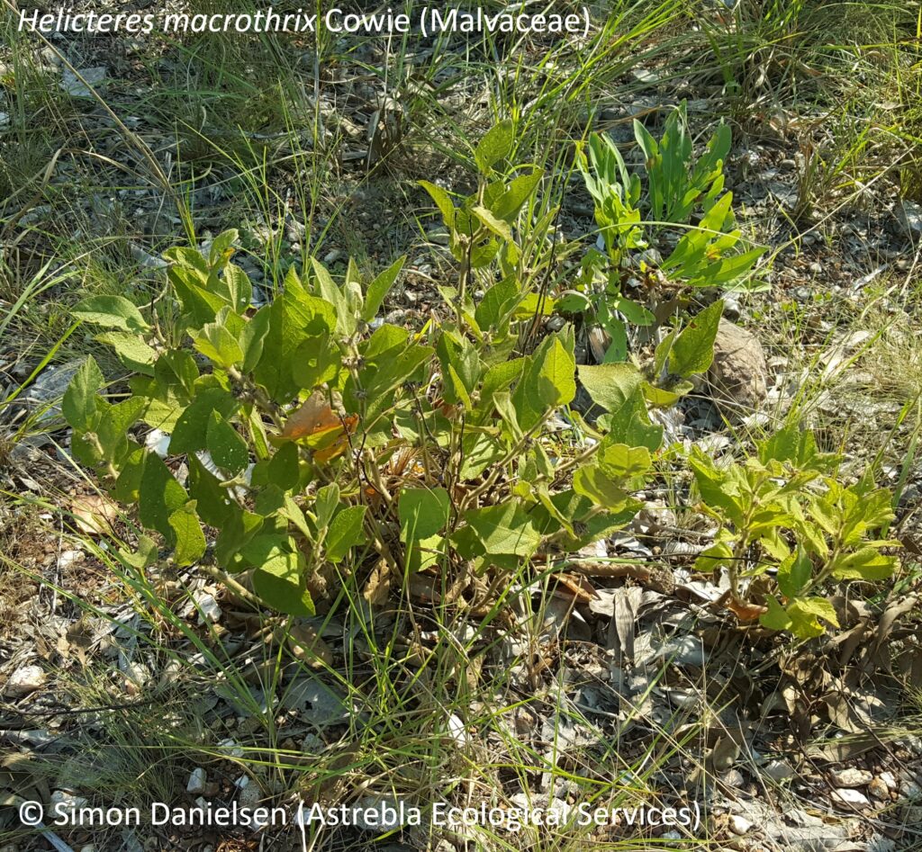
 We quickly located it, growing in the same grassland location as in 2000 (possibly from the same tuber). It was not flowering, however its presence in the same location as a previous confirmed record, and its conspicuously flanged/winged stems, suggested that is it highly likely to be O. turpethum.
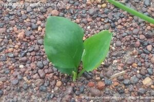 Typhonium praetermissum is a relatively cryptic perennial geophyte (i.e. a predominately subterranean herb) endemic to the Darwin/Litchfield area. It flowers and fruits in November and December, and appears to produce leaves only during the wet season, after which they quickly deteriorate and the plant disappears beneath the soil. The flowers are very delicate and exude an apparently unpleasant odour, but are quickly destroyed by ongoing wet season downpours, having a life of 1-3 days.
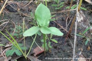 There are some major difficulties in locating and accurately identifying Typhonium spp.. Flowers are generally required to key to species, however these are rarely encountered. In addition, most species have leaves that display extreme morphological variations (as can be seen in the accompanying photos), making even tentative ID difficult.
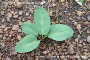 However, Dr Matthew Barrett of the WA Dept. of Biodiversity, Conservation and Attractions has developed a DNA barcoding technique that allows accurate and unambiguous identification to species of sterile material. Consequently, representative collections of leaf material were made from within the population of Typhonium individuals observed during our survey at Gunn Point and send to Dr Barrett for analysis and identification.
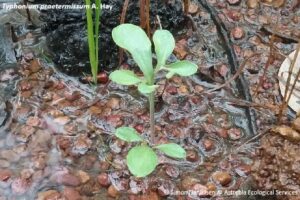 As a result, the identification of the majority of the population observed to T. praetermissum was possible. In addition, a small number of T. johnsonianum were also confirmed present. Interestingly, of the many hundreds of individuals of both species observed during the surveys, only one individual had fruit – all of the remainder were sterile.
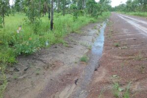 An interesting observation was that T. praetermissum was often present on disturbed surfaces, including spoon drains that are graded annually, and an old gravel pit.
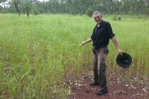 In the photo to the left, Bob Harwood is pointing out a population of nearly 100 individuals we observed in a large gravel pit beside the main road.
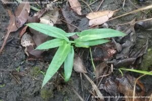 This species is very similar to T. praetermissum, but is less well known, being listed as data deficient in the NT. It has been recorded from the Alligator River floodplain, Kakadu National Park, and from the Humpty Doo and Noonamah areas. This survey represents the first collection from the Gunn Point area – as such, a range extension of approximately 30 km, which is relatively significant for a locally endemic plant with such a small range.
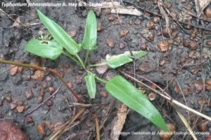 In general, T. johnsonianum displays less leaf-form variation than T. praetermissum – the leaves were invariably narrow triangular with a distinctive sagittate to hastate base, and a relatively short petiole. Some plants are more lanceolate, being cuneate to rounded at the base and lacking auricles.
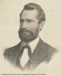 Dr Ludwig Leichhardt was the principal player in what must be one of the greatest scientific adventures in the history of European settlement of Australia. On 1st October 1844 he departed from Jimbour Station, the most western European station at that time in Queensland (Jimbour is just north of today’s township of Dalby on the Darling Downs in south east Queensland), to travel to Port Essington, approximately 300 km north east of Darwin. At that time, Pt. Essington was the only European settlement in northern Australia.
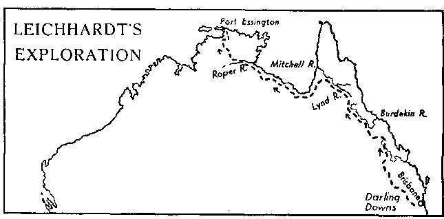 He arrived at Pt. Essington just prior to the wet season, on 17th December 1845, after traversing 4800 km. However, only seven men arrived at Pt. Essington – John Gilbert, an ornithologist and a protege of Gould, was speared and died at a camp near the Nassau River, not far from today’s Kowanyama on Cape York Peninsula.
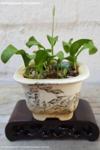 I first became aware of these tiny ferns when they began popping up in my hanging plant pots! Soon I had a whole colony, and they transplanted well into tiny bonsai pots, although I had no idea what they were – there were only tiny, fairly non-descript leaves with blades about 10-15 mm long.
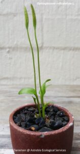 Those pictured here are Ophioglossum reticulatum L. (Ophioglossaceae), a tiny fern growing to 20 cm or so tall, and recorded from damp, shady situations among grass or on bare soil, often in eucalypt forest.
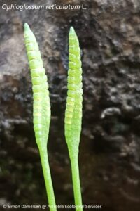 The fruiting spikes (actually modified leaves) are shown in this image – they are approximately 5 cm tall, and their presence mark the members of Ophioglossaceae as quite different from other ferns – they are referred to by taxonomists as either fern allies or fern ‘oddities’.
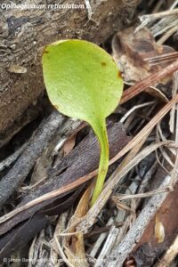 I also recorded this species on a survey I conducted in 2018 on the Evelyn Tablelands, growing on basaltic soil in Eucalyptus tereticornis open forest.
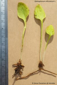 These tiny leaves were barely noticeable among the leaf litter, but were spotted by my eagle-eyed mate Dave Hunter, whose curiosity and ability to pick out tiny orchids and other cyrptophytes is fast becoming legendary!
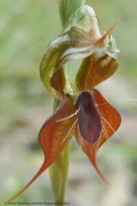
 Listed as endangered in Queensland and under the EPBC Act, this species is a rare slender twining vine distinguished by its small lanceolate, herbaceous, opposite leaves with purplish-red petioles and clear sap
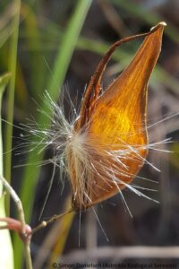 Tylophora rupicola was recorded from low closed and open forests, mostly grassy, on rhyolite slopes in association with Lophostemon confertus, Acacia aulococarpa, Eucalyptus granitica, Corymbia abergiana, E. reducta, Allocasuarina littorlis, Syncarpia glomulifera and C. citriodora, always slightly upslope of rocky minor watercourses (regional ecosystems 7.12.30d and 7.12.66c).
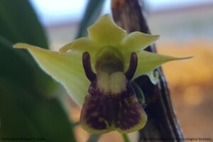 Dendrobium fellowsii F. Muell. (Orchidaceae) (native damsel orchid)
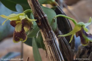 Dallachy collected it in the 1860s from the Cardwell area, and it was described by Baron Ferdinand von Mueller in 1870. Mueller named it after Thomas Howard Fellows, a short-termed Attorney General of colonial Victoria and later a Supreme Court judge. Dendrobium fellowsii is also known as Eleutheroglossum fellowsii (F. Muell.) M.A. Clem. & D.L. Jones.
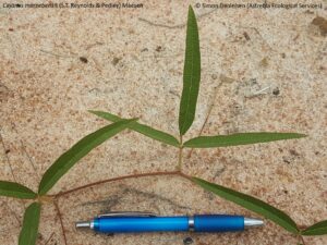 Cajanus mareebensis (S.T. Reynolds & Pedley) Maesen (Fabaceae)
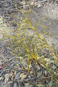 Macrozamia conferta (D.L. Jones & P.I. Forster)
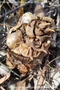
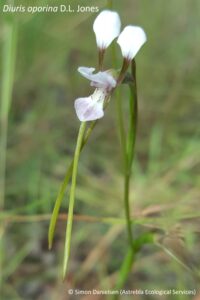 Diuris oporina D.L. Jones (Orchidaceae)
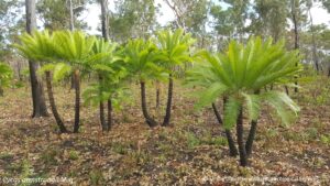 Cycas armstrongii Miq. (Cycadaceae)
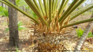 This cycad is relatively easily identified as it has flat to recurved (not revolute) leaflet margins, ovoid-globose pollen (male) cones and densely orange tomentose, pungent cataphylls (illustrated in the lower image – cataphylls are the young leaves). The mature adult leaf blades are green and shiny.
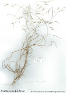 Aristida annua B.K. Simon (Poaceae)
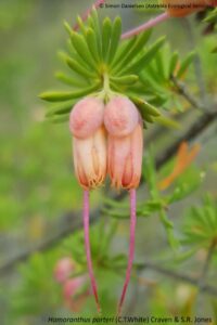 Homoranthus porteri (C.T. White) Craven & S.R. Jones (Myrtaceae)
 Homoranthus porteri is restricted to upland areas of rock pavement in ranges along the western fringe of the Atherton Tableland, with outlying populations at Mt Windsor (inland from the Daintree River), Mt Mulligan and the Hann Tableland.